How maps create nations
by Isabella Chua
Maps are powerful, albeit low-key, tools that inscribe and shape how people perceive themselves, or understand the outside world. By looking at the traditional maps of Siam (modern day Thailand), China and Japan, the influence Western technologies had on them, we can uncover their culture, beliefs, fears and priorities.
Imagine a map. Perhaps you will recall a world map hung unremarkably at the back of your classroom, or in this digital age, Google maps. However, a map is a versatile tool with many forms and uses. Just ask lexicographer J.H Andrews, who found a whopping 321 definitions of the world “map” from various sources between 1649 and 1996. Aside from the common usage of maps as representations of earth’s landscapes, we also use maps metaphorically, such as “mental maps”, or as diagrammatic representations in biology or engineering (“chromosome mapping” and “mapping flow-line systems”). Broadly, our modern understanding of maps is that they are representations of reality, be it locations or concepts. However that has not always been the case.
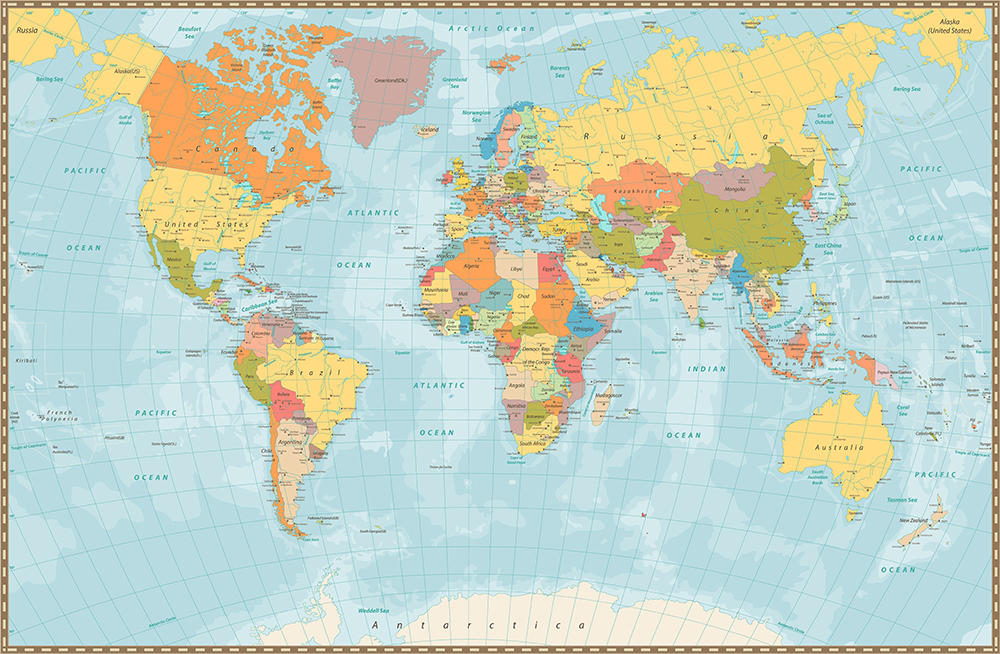
The map that we are familiar with, such as the spherical globe, uses the Mercator projection.

An example of a world map in the Mercator projection.
Proposed initially by Geradus Mercator in his Map of the World of 1569, and eventually published by his son Rumold Mercator in 1587 as a global projection, the Mercator projection allowed the globe to be measured in a latitude-longitude matrix for the first time. Relatedly, the invention of the marine chronometer by John Harrison in the 1761 enabled sailors to accurately calculate longitudes and reach their destinations. These highly precise clocks were important because a deviation of one second a day could throw a ship off-course up to 14km after a month.
What this means as a whole is that the earth’s surface was no longer something unfathomably vast and foreign, but conceivable to the human mind as calculable squares of unchartered and unclaimed territories.
This begs the question, how did people think about their world, or the “outside” world before these Western technologies were invented? Did countries even care about what was beyond their immediate boundaries? To address this question, we shall look at the indigenous maps of Siam, China and Japan, and their responses to these Western technologies.
Unlike modern maps that use scientific methods to accurately measure and represent the surface of the earth, indigenous maps were not limited to depicting the profane, material earth. Functionally, they were quite useless because they were usually not drawn to scale, and might even contain mythical locations. In fact, because indigenous maps were usually religious, they functioned more as creative mediums to illustrate a known fact or truth, through religious fables, or moral teachings for the layperson, than as an objective documentation of space.

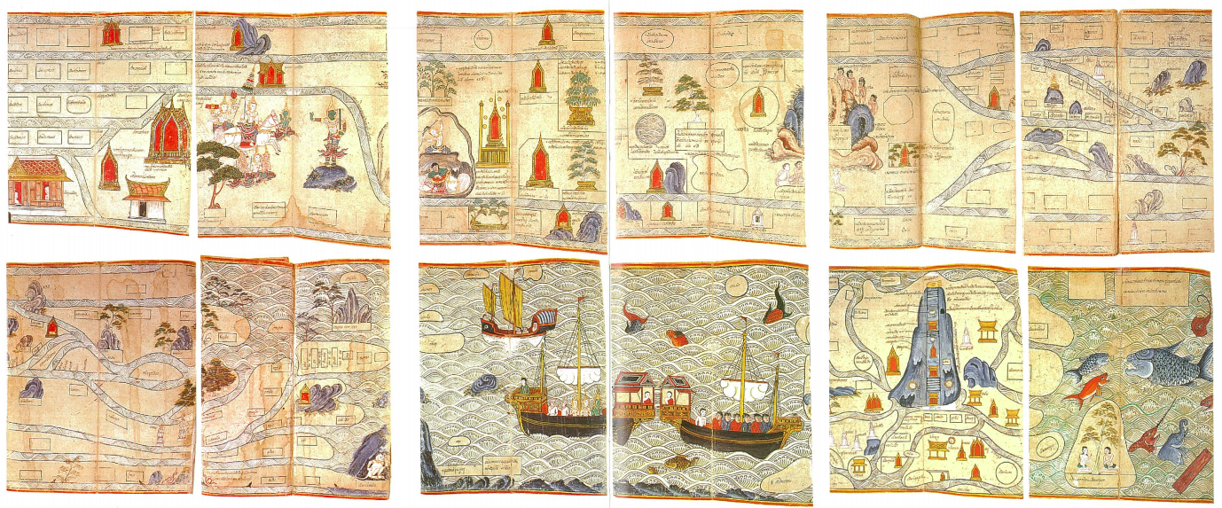
The Traiphum manuscript, 1771, the National Library of Thailand, taken from Thomas Suárez’s “Early Mapping of Southeast Asia”.
The Traiphum cosmography from the Siamese provides a good example. At first glance, it already differs greatly from the maps that we are familiar with. For one, there are images within the cosmography, and the routes do not seem particularly instructive. This is because it is a symbolic and pictorial representation of King Ruang’s “Three Worlds”, which is a Theravada Buddhism text about the religious universe where Thai Buddhists have traditionally lived. Within the Three Worlds, there are 31 levels, and where one resides depends on the merit accrued from one’s previous life. The damned are doomed to exist at the lowest levels of hell, whilst the most meritorious beings are at the highest.
However, this is not to say that the Traiphum cosmography only represents the spiritual realm; it also details the life of the Buddha in the human world, as well as the legends of Buddhism arriving at Suwannaphum, which we now know as mainland Southeast Asia.
This coexistence of the spiritual and the profane can be seen in panels one to ten, which details the story of Buddha’s life (each rectangle stands for a panel, to be read horizontally from left to right). You can see the tree under which the Buddha was born, the seven trees under which he rested, and the various places where he preached, such as the mountain of giants and demons, and a town of animals. Moreover, because stories take precedence over geography, the Traiphum can stretch from Lanna, or northern Thailand (panel five) to Lao and Vietnamese regions (panel five to seven), and to Ceylon, or Sri Lanka (panels nine to ten) in a seemingly continuous route.
Their conception of space then, is fluid and not confined by what is observable and material. Instead, the cosmography illustrates the Siamese culture’s subjective and imaginative understanding of the world where demons, sages, deities, nature and humans could all roam in different realms.

Huang Qianren. Complete Geographical Map of the Everlasting Unified Qing Empire (“大清萬年一統地理全圖”), 1796–1820, taken from Richard A. Pegg’s “Cartographic Traditions in East Asian Maps”.
The map above was created by the court during the Qing dynasty, Jailing period, from 1796 to 1820 in China. By this time, the Chinese were already aware of Western cartography methods and European maps of the world. However, these European maps were a threat to Qing’s grandiose self-image as the Middle Kingdom (中国) because they drew countries to scale. China no longer looked centralised or colossal.

Matteo Ricci’s Mappamundi, commonly known as A Map of the Myriad Countries of the World (“坤輿萬國全圖”). Image from Wikimedia Commons.
Indeed, when famous Jesuit missionary Matteo Ricci represented China in his correct to scale 1602 Mappamundi map as located to the west of center and inclined to the north, rather than at the center of the world, he was harshly criticised by Chinese scholars, whereupon one Ming scholar protested, “How can China be treated like a small unimportant country?”
Such concerns were reflected in the map below: the unity of the Qing empire, denoted by the various cartographic symbols, was juxtaposed against the intentionally vague geopolitical lines of the frontiers and beyond. With no clear land boundaries attributed to India, Russia, or Southeast Asia, all foreign entities were simply relegated to the fringes of China’s vast empire.
Yet, the incorporation of cartographic symbols in this map indicated that the Chinese were not closed off to Western technology. Rather, they co-opted it in order to lend an air of legitimacy to their conception of China as the Middle Kingdom, as we can see more prominently in Ming dynasty scholar Cao Junyi’s map below.

Cao Junyi. A Complete Map of the Nine Border Towns, Allotted Fields, Human Presence, and Travel Routes of All under Heaven (“天下九邊分野人跡路程全圖”), 1644, Harvard Yenching Library Map.
In his map, Cao included mathematical measurements of longitudinal lines and degrees, and estimated distances of various “barbarian” countries from the southern Ming capital (modern day Nanjing). The map also included sets of eight or so cartographic symbols to represent important administrative centres such as the districts (县), prefectures (府), and provincial capitals (省). The same cartographic care however was not extended to the world outside of China. While Cao’s map did acknowledge the existence of Europe and Africa, they were not drawn to scale.
Africa, located at the west side of his map, was depicted as only a tenth of the size of China, while Europe, located at the upper north-west of the map, was so minuscule it might as well have been an afterthought. In fact, the world outside of China was so negligible that even mythical lands, like the Land of Woman (女人国) taken from the Chinese classical text, Classic of Mountains and Seas (山海經) were included!
Yet paradoxically, because the Chinese emperor was the “ruler of all under Heaven”, he had a responsibility even towards these “barbarian” countries. Thus, maps of the 天下全圖 (loosely translated as “all beneath the Heavens”) genre, such as Cao’s, were usually prefaced by a text detailing the arduous journeys these “barbarian” envoys embarked on to present themselves as vassals to the Qing dynasty.
If China could be characterised as the pompous host who expected guests to pour in from different parts of the world to pay tribute, Japan was the hermit isolated from the world. They could afford to, for they had been economically self-sufficient and had a long history of prolonged independence. Their isolation was even institutionalised through the seclusion policy in the Tokugawa period, where three edicts (the Exclusion Decrees of 1633, 1635 and 1639) were issued to diminish non-Japanese influence, such as Christianity. This meant that there was neither the need nor the interest in mapping the world beyond Japan. Thus Japanese Buddhist World maps continued to enjoy enduring popularity from the 16th to mid-19th century despite the availability of newer European world maps from the 16th century.

Rokashi Zuda (Hōtan). Map of All the Countries of the Jambudvipa (“Nansen bushū bankoku shōka no zu”), 1710, John Carter Brown Library Map Collection, Brown University.
One such map was the Map of All the Countries of the Jambudvipa by Hōtan, a scholar-priest in 1710 during the Edo period. This is the map of the physical dimension of the Buddhist world, where Jambudvīpa is the continent of our habitable world. Jambudvīpa is a Sanskrit term where Jambu is an imaginary tree believed to be found in the far north of India, while dvīpa”meant land. The Buddhist view of the world was that the world consists of three countries, namely India, China and Japan, with India occupying the superior position as the Holy Land of Buddhism. It is unsurprising then, that countries outside of this triad were resigned to the periphery in Hōtan’s map.

Upper left corner of Map of All the Countries of the Jambudvipa depicting Europe, Holland, Italy, France and England. Imaginary lands, such as the “Land of Dwarves” (小人) and “Land of Long Hair” (長毛國) from the Chinese classic text, “Classic of Mountains and Seas” (山海經) are also depicted. Waseda University Library.
For instance, even though Hōtan introduced both European and American countries into his map, they were distorted and removed from reality. To Hōtan, these newly reported countries were but “mote-like countries in Jambudvīpa”, which were as “small as a millet-grain” as written in the Buddhist Scriptures, and held no meaning in this Buddhist conception of the world. The marginalisation of Western countries continued to be encoded a century later, as seen in Outline Map of All Countries on Earth, by Yoshiharu Koyano in 1809.

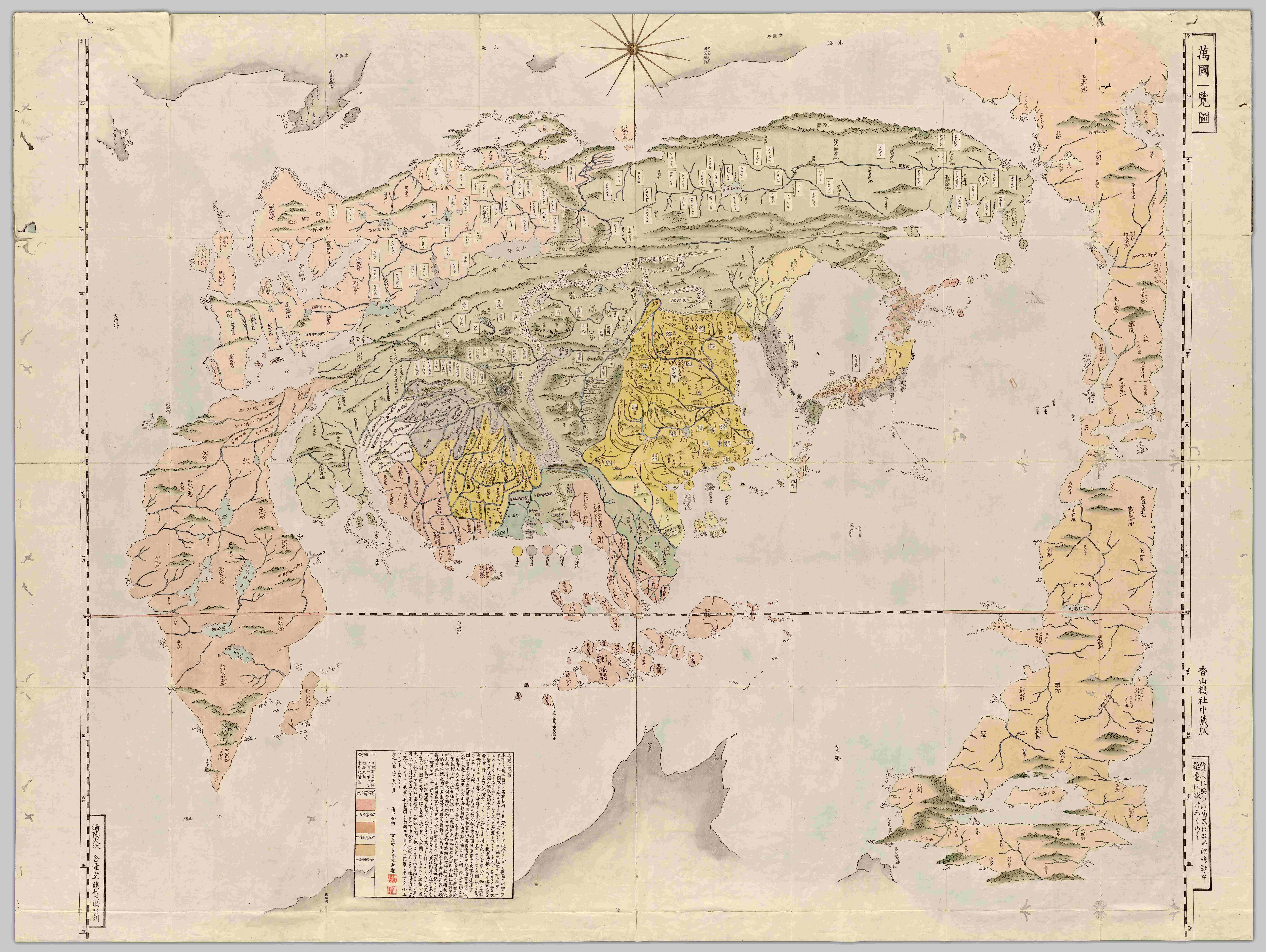
Yoshiharu Koyano. Outline Map of All Countries on Earth (“Bankoku Ichiran Zu”), 1809, University of British Columbia Library, Rare Books and Special Collections.
This map was ostensibly simplified so that children could understand it, as the new map from Holland was considered too detailed. The deformation of continents, except for Asia at the center of the world map, was further justified by the limited space of the map. Yet the inflated size and placement of Japan with China and India side to side echoed the old Asia-centric conception of the world.
By the 19th century, modern warfare necessitated the displacement of indigenous maps for Western styled maps as they depicted the actual geography of the world, and also allowed space to be conquered through mathematical calculations of coordinates. This meant that leaders of countries could actually plot and conquer territories, or even more fundamentally, demarcate which areas belong to them.
Rather than use maps to propagate information about themselves, Western mapping techniques encouraged indigenous leaders to venture into new territories, erect boundaries, and claim the space as their legitimate space. While indigenous maps encouraged introspection into their own culture and beliefs, modern mapping techniques and conventions, such as the bird’s eye view in modern maps, compelled them to see themselves as part of the larger world.
This shift in perception was most evident in Siam in the 19th century due to a confluence of factors. First there were imperialist advances in Burma and China, which propelled the un-colonised Siam, to safeguard themselves through the acquisition of the more influential and superior Western cartographic knowledge. Secondly, Mongkut (also known as King Rama IV), was a strong advocate for Western science and had dismissed the aforementioned Traiphum cosmography of the 18th century.

Photograph of King Mongkut on His Throne, by John Thomson. Image from Wikimedia Commons.
Mongkut’s admiration for Western sciences such as astronomy and almanac created an environment receptive to science. Western envoys visited Siam with globes and maps of many countries and cities, which enabled Siamese elites to become familiarised with foreign ideas and scientific instruments. Gradually, they began to want Siam to be depicted along with the other “civilised” countries in these Western maps as well, because geographically, Siam was still considered terra incognita (unknown land).
Mongkut’s son, the eventual King Chulalongkorn, took his father’s reverence of Western sciences further. In 1892, modern geography became a subject at every level of secondary schools. Instead of epic fables of Thailand’s heroes, students now learned about the earth, the solar system, and other natural phenomena. They were also equipped with cartographic skills like drawing up plans for a town, a house, or a village, and were taught to read maps.
Significantly, the Siamese begun to call Siam Prathetthai, rather than Muang Thai by 1941. Muang was a general description of a community, city, or country. It was a vague term that did not specify any structure, size or degree of power. Comparatively, to conceive Siam as a prathet, or nation, meant thinking in modern geographical terms, because a nation is a land demarcated by boundaries. This positioning of Siam as a nation in a spherical world was a great departure from the Three Worlds in Traiphum cosmography.
As we have seen, maps are not neutral documents. In traditional maps, cultures created a visual representation of their place in the world.
But what about modern maps? What were they seeking to achieve through their seemingly objective and scientifically rendered representation of the world?
King Chulalongkorn, whether consciously or not, understood the supposed neutrality of modern geography, and exploited it for his conquests. From the 1880s till the middle of 1893, surveyors and mapping technicians accompanied the Siamese troops in their suppression of the Ho (rebels from China) in Laos. King Chulalongkorn implicitly understood that a brute takeover would not be sufficient, because the rules have changed and domination over a land was now best done through administrative means, like mapping. Thus a team of mapping officials was commissioned by the King to gather accurate knowledge of the localities and people in Laos, and subsequently these data were encoded into maps whereby territories could be negotiated and divided with the French.
The power of mapping lies in making artificial boundaries, imposed and negotiated by leaders, formal and “natural”. Maps make it seem like the world has always been “as it is”, instead of the product of a concerted effort by leaders and cartographers who actively construct the geography of their nations.
So the next time you chance upon a map, do not see it as a dry and factual representation of our empirical earth. Instead, see it as the crystallisation of many untold battles, worldly aspirations, and painstaking cartographic work. More poignantly, they also represent the sacrifices cultures had to make in replacing indigenous representations of the world, in order to fit into the contemporary mould of maps.


